Let me first preface this article with a few disclaimers. This is like the beginning of all the painful seminars and webinars I sit through to learn how the state of California is making life even more miserable for businesses when the lawyer giving the meeting says “This is not legal advice, we encourage you to contact your own legal counsel for specifics relating to your situation.”
Disclaimer
With that in mind, I am not a CFI, I don’t have any professional experience in flight training or the regulations related to flying, and I encourage you to seek answers to your own personal situations from appropriate sources. For those of you who remember the commercials from 1998-2009, it has also been a long time since I stayed at a Holiday Inn Express. That being said, these are the things that I have found work for me, and why I do them. Oh, and I have also been reminded that controllers in certain areas of the country are not as friendly and helpful as the ones we have here in Southern California, so your mileage may vary.
Why file VFR if you will need IFR
First of all, why file a VFR flight plan and depart if you know that you are going to need to be IFR at your destination? For me it is when it is VFR at my departure but IFR or forecast IFR coming back into the LA Basin and for different reasons I don’t want to fly the entire thing IFR. It could be that I’m departing an untowered field and it is easier to pick it up in the air. It could be that I don’t want to deal with the routing I know they are going to give me to depart and I would rather just be VFR and stay outside of the different airspace on departure. And often out here in the mountainous southwest where the MEAs are very high, I don’t want to or possibly can’t fly at the required altitude.
There are also times that it would put me in clouds under icing conditions, so it is better to stay VFR below the clouds. For example, on a recent flight from St. George back to SoCal, they would have put me at 12,000′, right in the clouds at below freezing temperatures. Instead, I cruised along at 10,500′ below the overcast, picked up my IFR over the Hector VOR (HEC) where they had me descend to 10,000′ for the STAR.
A Pop-Up IFR
You can always try to get a pop-up IFR, I still do that on occasion and did on a recent return flight from Phoenix. The forecast was for the marine layer to burn off a few hours before our arrival. It was a little over a 2-hour flight and it hadn’t burned off by the time we were leaving, but if you know about the marine layer it doesn’t take long once it starts to burn off to go from overcast to blue skies.
We were still about 80 miles east of Palm Springs when I could see a layer of clouds in the Banning Pass between the San Jacinto and San Gorgonio peaks. That isn’t really cause for concern, but I could also see the clouds spilling over the ridgeline south of San Jacinto, and the ADS-B weather was showing overcast in the Inland Empire and broken at 4,000′ at Fullerton (KFUL). If you’re not familiar with SoCal terms, the Inland Empire is the area between the coastal mountains in Orange County and the San Bernardino Mountains to the north and the San Jacinto mountains to the east. It has the cities of Corona, Riverside, Ontario and San Bernardino along with a multitude of smaller cities.
The “IE” as they call it, also usually has clear skies long before the coastal cities due to the marine layer getting hung up on the coastal mountains and the higher temperatures. So, if it was still overcast there wasn’t much hope of it clearing out in the next 45 minutes of flight. I could drop down and stay under the overcast, the airports were all showing it around 4,000′ so it wouldn’t be scud running. Alternatively, I could pick up IFR for an easy approach through 1-2,000′ of clouds breaking out early.
I chose to try and get a clearance, which left me with two more choices. I could wait until I was past the Banning Pass and talk to SoCal Approach there or try my luck with the SoCal Approach sector covering Palm Springs. I knew the closer I got to LA the busier the controllers would be, so pulled up the frequency for the sector and called them up. It was an easy clearance to copy down and just like that we were IFR.
How to pre-plan picking up IFR en-route
But this isn’t an article about pop-up IFR, it is about intentionally planning to pick up IFR in the air before taking off. However, it does bring up a point about where I plan to pick up my clearance. I always try to plan it when I am in an area controlled by Center and not Approach Control. Why Center Control? Well, if you’ve ever listened to the Opposing Bases podcast, they like to poke fun at the Center Controllers who have nothing to do all day except give out frequency changes.
That isn’t entirely true, but my experience on the airwaves is that Centerland is much quieter on the radios than Approach territory. I have on occasion keyed up the mic to make sure I hadn’t missed a handoff, even though I’m also monitoring Guard, because it has felt like an eternity since I last heard a radio call.
First, I file a VFR flight plan for the entire route of flight so that I can get a weather briefing for the entire flight. Then I look for an airport or VOR somewhere well before the point that I will need to be IFR. If it is an airport, I look at the communications information to see if there are approach/departure frequencies listed. If there are none listed, then the remarks will show which facility provides approach/departure control services. If I am filing from a VOR, I check the airports close to the VOR to see who provides the services.
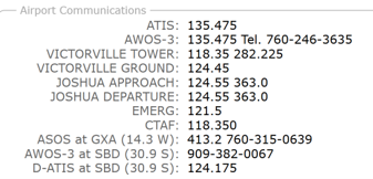
Here is the information for Victorville (KVCV) showing Joshua Approach providing services:
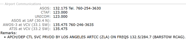
And here is the information for Barstow/Daggett (KDAG) showing LA Center providing services.
Now that I have the en route point where I want to pick up IFR decided, I file an IFR plan from there to my destination. I set my departure time to be the time I anticipate being over the fix. This is another reason for the VFR flight plan that I filed. I make sure to include the fix where I will pick up IFR in the VFR plan so I can see the flight time from my departure and know what departure time to use when filing the IFR segment.
A helpful tool if you aren’t sure what route to file is www.fltplan.com. If you let it create a flight plan it will also list the most recent plans filed and used, but it must be from airport to airport, putting in a VOR as the departure will cause an error.
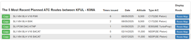
Here’s an example of recent routes between KFUL and KIWA from www.fltplan.com of the flight we made a few weeks ago.
You could also just file direct and see what ATC gives back to you.
There’s one more step I will do after filing my flight plan and prior to getting my briefing. I go to www.flightaware.com and look up my planned flight. In the Flight Data section, it will list the route. I then go to www.1800wxbrief.com, log in, go to the flight, and amend my route to match what FlightAware is showing. This isn’t a 100% guarantee, but I would say at least 75% of the time it results in a clearance of “Cleared to xxx via as filed,” those two sweet words.
On my notepad before taking off I will copy down the CRAFT with a couple of lines for the route and the fixes spaced out leaving room in between for changes. This way when I get the clearance, I can quickly cross out any changes (there usually aren’t many) and it saves me a lot of fast writing. My handwriting is terrible and the faster I write the worse it gets.
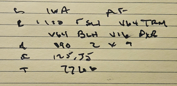
This wasn’t picking up clearance in the air, but an example from our last flight from KFUL to KIWA. I wrote out SLI V64 TRM V64 BLH V16 PXR in the routing. I left room before the SLI because they always say “Left turn heading 120 radar vectors to Seal Beach” for a departure on 24 out of KFUL. When he gave me the clearance it was “On departure, left turn heading 120, radar vectors to Seal Beach, then as filed.” I scribbled “L 120 r” before the SLI and then “AF.” The rest of the shorthand is “2 x 9” for the altitude. I had written down 090 as my filed altitude and the “2 x 9” for the “climb maintain 2,000 expect 9,000 one-zero minutes after departure.”
Now you have your VFR and IFR flight plans, just get your briefings and get in the air. When you are approaching or at the pre-planned fix where you are going to pick up your clearance call up ATC. You can give them the whole bit in the first call, i.e., “LA Center, Mooney 1015 Echo is 10,500′, 5 miles north of Hector and would like to pick up my IFR,” but I have found that usually results in something like “What was the last plane calling?” I have found better results with just “LA Center, Mooney 1015 Echo with a request.” The typical response is “Mooney 1015 Echo, say request,” at which point I give them my position along with “I’d like to pick up my IFR, there should be a plan on file.”
Hopefully there is something helpful here, keeping in mind the disclaimer from the second paragraph and the fact that I haven’t been in a Holiday Inn Express for a few years.