Flight 23 – August 18th
I scheduled a flight after work and all day I was looking at cloudy skies. The forecast said it should still be cloudy at 6pm when we would be flying so I was hopeful for some more actual IMC. When I got to the airport after work the skies had lifted and broken up a little but there were still plenty of clouds. The ATIS (Automatic Terminal Information Service) at KFUL was reporting a scattered layer at 2,100′, a broken layer at 3,300′, and overcast at 4,700′.
My CFII arrived and I asked him what the plan was. “Why don’t we file and fly to Palomar? It looks like that should be in the clouds most of the way,” he said.
“Do you have a flight after mine?” I asked. We only had two hours blocked out and between the planning, briefing, and flights it was going to take a little more than two hours.
“Nope, if we go over it’s fine,” he replied.
Just as I had on the previous flight I filed the IFR plans from my phone and got my briefings. I pulled the plane out of the hangar and we taxied to the fuel pumps. I hadn’t planned on that long a flight, and while we could have made the flight there and back and still had “legal” IFR reserves it would have been less than my personal minimums. IFR reserves require that you can reach your destination and alternate and still have 45 minutes of fuel remaining at cruise power. I burn a little less than 10 gallons an hour in cruise so legally I only need to have 7.5 gallons remaining, but my personal minimums is to always land with at least 10 gallons of fuel on board.
After filling the tanks we taxied to the run-up area and upon completing the run-up and pre-takeoff checklists I called up Ground for our clearance.
Me: “Fullerton Ground, Mooney 78878 in the southeast run-up with Mike, ready to copy IFR.”
Ground: “Mooney 78878, you are cleared to the Palomar airport via, on departure left turn heading 120, vectors to Seal Beach, Victor 64, Victor 363, DANAH, Victor 23, Oceanside, Direct. Climb maintain 2,000, expect 5,000 one-zero minutes after departure, frequency 125.35, squawk 4723.
On my knee pad I had written:
C – CRQ
R – L120 vSLI V64 V363 DANAH V23 OCN D
A – 020 050 10m
F – 125.35
T – 4723
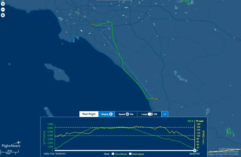
After the readback we received taxi clearance and then takeoff clearance from the tower. As we began the turn to a heading of 120 we were handed off to SoCal Approach and she cleared us to 5,000 on the 120 heading. As with most other times I have been on an IFR plan in the LA Basin I wasn’t flying much of the cleared route. After a couple of heading changes we were cleared direct to DANAH and then as filed.
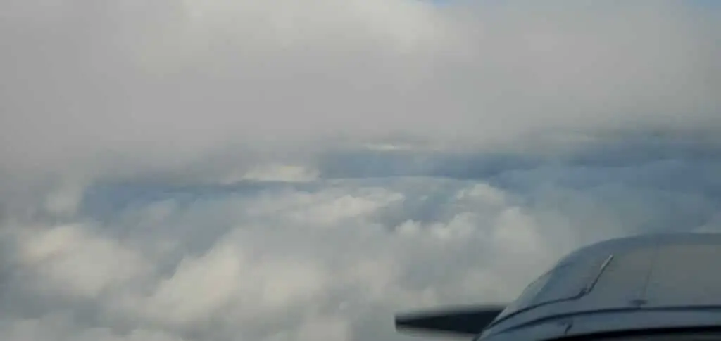
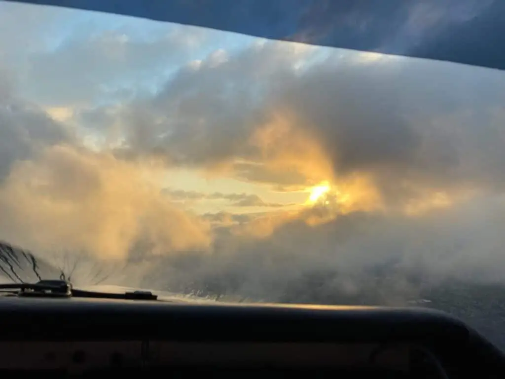
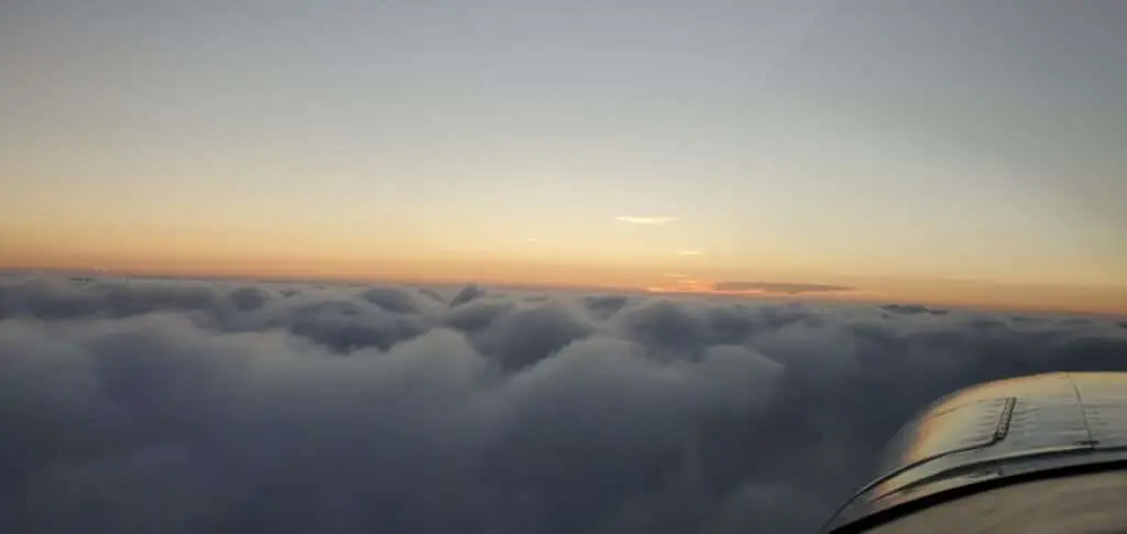
I was so bummed that I had not brought my camera to mount under the wing. We had climbed into the clouds soon after taking off and would spend the better part of the next 51 minutes of flying inside the clouds. We would be in solid clouds with the water droplets running up the windshield and then break out of the cloud bank in between layers with wispy clouds, filling the open area, clouds below, clouds above, and then it was back into the next bank of clouds. The views were absolutely stunning.
The tops of the clouds were maybe a couple hundred feet above us and every now and then you would get a little sunlight bleeding through from above and to the west as the sun dipped towards the horizon.
ATC was busy, and so was Palomar. ATC gave us vectors to delay for sequencing which had us on a heading of 070. We broke out of the clouds for a moment and then back into them as we continued along. Flying at 5,000′ I was watching us get closer and closer to the 5,710′ mountain in front of us. The red on the GNC355 in the panel was showing 10 miles ahead and both tablets were blinking red in front of us.
We had been talking to the same controller from the time we had just passed John Wayne Airport and she had a lot of traffic she was working with. Going through my mind were a few crashes that occurred when planes were vectored into terrain. At a groundspeed of 160 mph we were moving along at a nice clip and I decided that if we weren’t given a new heading by the time we were 8 miles from the mountain I would call up ATC and request a new heading. Just before I was ready to key my mic ATC called us up.
SoCal: “Mooney 78878, make a left turn, left turn (she emphasized left turn) heading 260.”
Me: “Left turn heading 260, 878.”
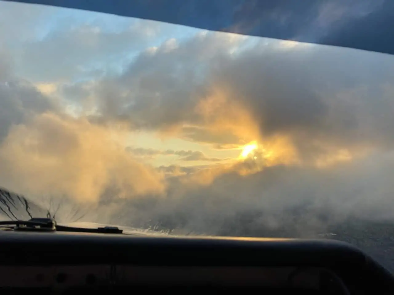
Two more heading changes and we were intercepting the final approach course and descending through the clouds. We crossed the final approach fix at 3,247′ and continued the descent, breaking out of the clouds at about 1,400′ and about 2.5 miles from the runway. It was right in front of us, lit up, and beautiful. I have 58 approaches in my logbook but this was only my 2nd in actual IMC. It is one thing to pull the foggles off and see the runway, but quite another to come out of the clouds and see the lights there in front of you. My CFII Captured the photo below on final into Palomar, I hadn’t even noticed how beautiful it was at the time because I was focused on the instruments and staying on glideslope.
Upon exiting the runway we were cleared to taxi back where I stopped in the runup area to configure for the return flight and pick up our IFR clearance. I had filed 4,000′ on the return leg knowing that would put us in the clouds but was disappointed when my clearance included “climb maintain 2,000 expect 6,000 one-zero minutes after departure.” We had been just below the tops of the clouds at 5,000′ and 6,000′ was going to put us in clear sky which meant back on the foggles.
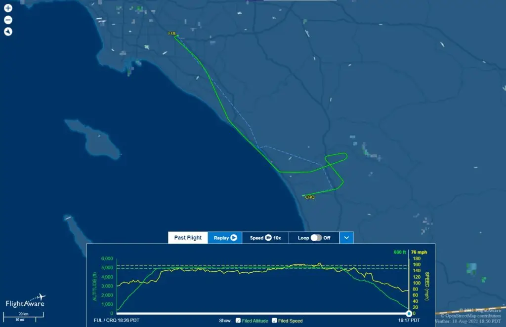
Sure enough, after a short climb through the clouds we were on top of the layer and I reluctantly put the foggles on, already missing the experience on the way down of flying in actual IMC (Instrument Meteorological Conditions). Passing north of the restricted areas above Camp Pendleton we were given vectors toward the RNAV 24 approach into KFUL and once we began our descent we were back into the clouds and the foggles came back off.
It was beautiful, in and out of clouds, and with the sun already below the horizon I would catch a glimpse of lights on the ground every now and then. Eventually we were given a final heading to intercept the final approach and cleared for the approach. We crossed the FAF (Final Approach Fix) of AKTAQ at 2,000′ and at about 1,700′ we broke out of the last of the clouds to see the runway out in front of us.
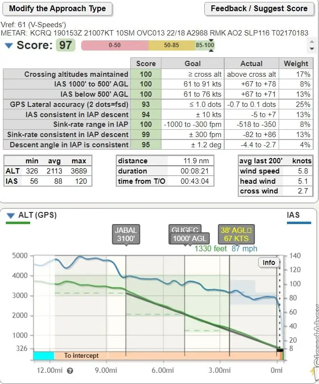
Flying in actual IMC was easier than the simulated IMC with the foggles on. Being able to take in the whole cabin in your peripheral vision and to just glance over at the GPS in the radio stack instead of having to turn your head makes a huge difference. The numbers from the approach into Palomar were great, a 97 from Cloudahoy.