Most of Wednesday was rainy and overcast, but the day to actually fly through the clouds was not to be yet. I met up with my CFII after work for another evening training flight. By the time we met the ceilings in the area were between 4,500-5,000′. He said that he had considered filing an IFR plan and flying it to get some actual instrument time, but with the ceilings where they were and the icing level forecast at 6,000′ it would not be a wise move.
I told him I was just as happy to go and shoot an approach or two at one of the closer airports and continue to get used to the radio work associated with flying IFR (a bit different than flight following) and continue working on flying headings, intercepting courses, and holding altitudes. We decided that we would take off, fly the RNAV GPS approach for runway 29R at Torrance (KTOA) and then hopefully fly the full missed approach including the hold.
I had pre-flighted the plane before he arrived so after we briefed the plate for the RNAV GPS 29R approach at KTOA we climbed in the plane and got going. Checklists were completed, the run-up was completed, and I called up Ground for flight following to KTOA to get a squawk code assigned and an easy handoff to SoCal Approach.
The winds were out of the east so runway 06 was in use which meant a right turn to heading 120 on departure prior to contacting SoCal. After takeoff my instructor took the plane while I put the foggles on and then I took the plane back from him. I asked SoCal for the approach and said that we wanted to fly the whole approach beginning at Seal Beach Vortac. I didn’t want them to just vector us to the final approach course. ATC advised to “Maintain VFR” and resume our own navigation.
I tuned in to get the ATIS (Automatic Terminal Information Service) for KTOA and along with the weather was a message that the tower was operating on reduced hours and had closed at 6pm. We had hoped that the tower would coordinate the handoff back to ATC so that we could fly the missed approach because the hold is in LAX’s Bravo surface area. With the tower closed we would be on our own to reestablish clearance with SoCal Approach.
Once established on the final approach ATC turned us loose to squawk 1200 (VFR) and change to the advisory frequency for KTOA. I continued down the approach trying my best to stay both on glideslope and centered horizontally. It was a pretty smooth approach most of the way but we did get bounced around just a little along the way.
“That’s just from the oil refineries” he said as we suddenly bounced around a little, and just as soon as it started it went away and was smooth again. My instrument scan is improving with every flight and it was much better on this one, but there is still improvement to be made. I did well staying on the glideslope but wandered back and forth from side to side of the lateral guidance.
“200 feet to go.”
“100 feet to go,” he said as we approached the DA (Decision Altitude).
“Ok, look up.”
Before I explain what I saw as I tilted my head back to get a view out the windscreen with my foggles still on, I have to explain (at least to the non-pilots) what is an LPV approach. LPV stands for Localizer Approach with Vertical Guidance and is a precision GPS approach. Because it has vertical guidance the minimum altitude that you can descend to while looking for the runway environment. For this approach that we were flying the minimums are 367 – 1/2 which means an altitude of 367′ and 1/2 mile visibility. Incidentally, 367′ MSL (Mean Seal Level) is 270′ AGL (Above Ground Level) or the height you are above the ground. I also have to say that when flying a VFR approach by the time I am about 300′ above ground level I am not looking at my altimeter any more but am focusing on the runway in front of me, so I never really put together in my head how close to the ground 300′ is, after all I am about to land at that point.
Well, when he said “Ok, look up,” and I tilted my head back I saw that we were about 50′ right of centerline with the approach lights and runway lights right there in front of us. With a 150′ wide runway on short final it would have been easy to slide over to the centerline before touching down. I had two thoughts that went through my head at almost the same time. The first one was “It’s right there, that’s awesome,” referring to the runway. the second thought was “Wow, we are low and close.” We weren’t low as in below the glideslope, it was just the realization that flying all the way down to LPV minimums gets you very close to the runway.
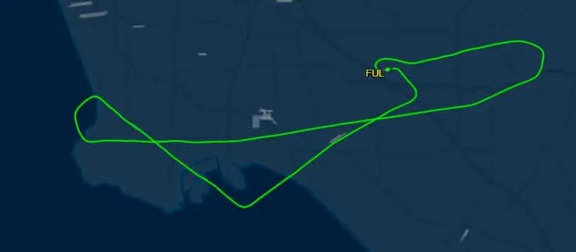
That was all the thoughts I had time for as I put my head back down to focus on my instruments and pushed the throttle in to begin flying the missed approach. I pulled the gear up, got the plane all cleaned up, and began the climb out as my CFII worked the radio to try and get us clearance to fly the hold. LAX was landing to the east (a rarity) and the frequency was busy. After two calls of “Approach, Mooney 78878, request,” with no acknowledgement he gave up and gave me a heading to fly to keep us out of the Bravo Airspace.
We headed back east and got a new squawk from ATC and requested the RNAV for runway 24 into Fullerton. ATC gave us vectors to fly and we picked up the final approach course about five miles before the Final Approach Fix where we were handed of the KFUL Tower. They were still using runway 06 at KFUL so we flew down to the MDA (Minimum Descent Altitude) of 900′ before he took the plane so that I could take the foggles off. There was runway 24 right in front of us (much further away than the LPV minimums at KTOA) and we circled around for left traffic to land runway 06.
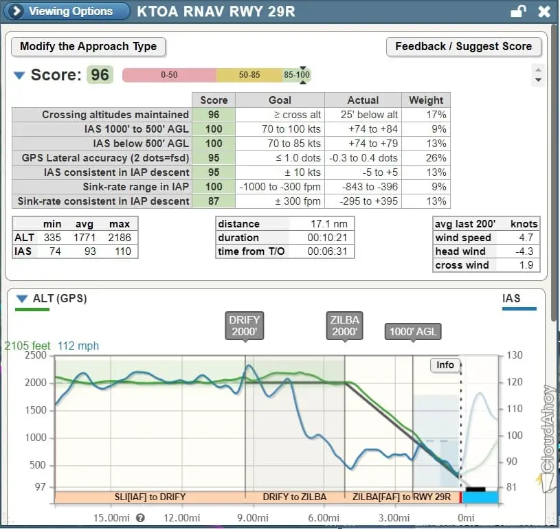
I know I keep saying it, but I’m still amazed at flying around without looking outside the plane. I’m continuing to see improvement in my instrument scan which is improving my ability to hold altitudes and headings. there is still a long way to go, but it is improving with each flight. There is a great app called Cloud Ahoy that will provide a debrief of procedures flow. When I got home I looked up the flight and was excited (and surprised) to see that I had scored 96 out of 100 on the approach into KTOA. I felt like I wasn’t that accurate and feel like I can and will do so much better as we continue my training.